The archival find that rewrote game history
For nearly a century, a tidy marketing line from Parker Brothers stood unchallenged: “The first board game ever published in America” was its 1843 import, The Mansion of Happiness. Then a game collector opened a box at the American Antiquarian Society in 1991 and found something older—printed in New York in 1822 by F. & R. Lockwood, a cartography firm. The title was as plain as its mission: The Travellers’ Tour Through the United States.
That discovery didn’t just adjust a footnote. It moved the starting line for U.S. board game history back two decades and gave credit to a homegrown design shaped by geography, not moral sermons. The Travellers’ Tour belongs to a European genre of educational games that used maps as boards, but this one was tailored to the American moment—24 states strong, fresh off the additions of Maine and Missouri, and eager to see itself in print.
Calling it America's first board game is accurate in the sense that it’s the earliest known board game printed in the United States. It arrived at a time when parlor play was taking off among middle- and upper-class families, especially around New Year’s, which was then the main gift-giving holiday. Booksellers stacked their counters with seasonal amusements—puzzles, paper dolls, themed pamphlets—and, increasingly, games that doubled as lessons.
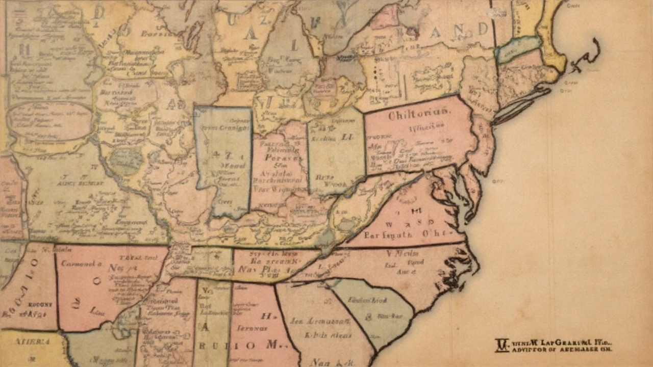
Lockwood’s map wasn’t just wall decoration. It was homework in disguise. The board showed a detailed United States dotted with 139 numbered municipalities, each linked to a line in the rule booklet. Players moved not by rolling dice, which many parents associated with gambling, but by spinning a teetotum—a small top with numbered faces. Name the correct city, move on. Miss it, and you linger in place while others travel the young republic faster than any stagecoach could.
How it worked—and what it taught
The rules were simple, the demands were not. Players raced to be first to reach New Orleans and, in a harder variant, had to recite populations along the way. The winning move required stating the population of New Orleans—printed as 10,000 in the 1822 game—before claiming victory. The figure underlines a quirk of early educational games: numbers could lag reality, but accuracy wasn’t the only goal. Repetition, recognition, and pride in place mattered just as much.
Geography games were the TikTok explainers of their day. They turned rote facts into a social challenge and smuggled civic knowledge into family fun. In a living room lit by candles, a child spinning a top and rattling off “Albany, Providence, Lexington” was learning how the country fit together—rivers, ports, state capitals—and how quickly that map was changing.
The choice of a teetotum says a lot about the culture that made the game. Nineteenth-century Protestant households often frowned on dice, which signaled gambling. The teetotum—a numbered spinner used in many parlor games—offered chance without the baggage. That’s why you find it across early children’s games in Britain and America.
What set The Travellers’ Tour apart from many European predecessors was its framing. It wasn’t an ethical ladder to virtue, like The Mansion of Happiness. It was a nation-building exercise. Landing on towns in Missouri or Maine suggested a country on the move, and a family game table was a low-stakes place to absorb that story. A map at home was still a minor luxury in 1822; a map you could play was even better.
Here’s what the boxed experience likely included and asked of players:
- A printed U.S. map serving as the board, with 139 numbered stops across 24 states.
- A teetotum (a small spinner) instead of dice to determine movement.
- Rules requiring players to identify each numbered municipality by name; an advanced mode added population figures.
- A fixed destination—New Orleans—and a final recitation of its stated population to win.
It fit the retail habits of the era, too. Booksellers, not toy shops, were the go-to for this kind of entertainment. Educational games sat next to atlases and primers on shelves built for holiday shoppers. Geography had cultural momentum thanks to popular school texts—Jedidiah Morse’s American geographies, for example—and the post office and turnpike networks were knitting the states together. A game that mapped the whole thing felt timely and useful.
So how did the Parker Brothers line survive for so long? Simple: survivors write the slogans. Parker Brothers, founded later in the nineteenth century, had the marketing muscle and a catalog that reached into most American towns. When the firm acquired rights to the U.S. edition of The Mansion of Happiness in 1894, it inherited an English hit and positioned it as foundational here. Without an older American-printed board game in public view, the claim stuck.
The 1991 find at the American Antiquarian Society changed that. It didn’t diminish The Mansion of Happiness, which still marks an early moment in U.S. publishing of European-style moral games. It just restored the first known American-printed board game to a title it earned on its own terms—designed by American mapmakers, focused on American places, and sold into American parlors.
The Travellers’ Tour also helps explain the path from educational geography to modern pastime. Before mass-market hits like Milton Bradley’s The Checkered Game of Life (1860) and much later, property-trading juggernauts, families bought games to practice something: reading, counting, navigation, manners. The idea that a game could “teach while it entertains” is not new at all; it’s the foundation.
There’s another lesson tucked into this story: how history hides in packaging and paper. One long-forgotten box in an archive can upend a century of company lore. The Travellers’ Tour reminds us that American play has always been tied to how Americans saw themselves—expanding borders, new states on the map, cities rising. Spin the teetotum, say the name, make your move. In 1822, that was play. It was also practice for citizenship.
Today, the game reads like a snapshot. Maine, just two years into statehood; Missouri, one year in. New Orleans as the glamorous finish line, even if the printed population lagged behind reality. The specifics date it, but the impulse behind it—turn the news of the nation into a family challenge—feels familiar. We still like our facts with a little competition built in.
Credit, then, where it’s due. F. & R. Lockwood weren’t just map sellers. They were early game designers who realized that a country hungry to see itself on paper might want to play on that paper, too. And that a simple top could spin children through the United States faster than any textbook.


